
Ebey’s Landing, Whidbey Island — Photo by Joe Tobens
While Rainier is perhaps the Pacific Northwest’s most iconic place to hike, Washington has more than 9,000 miles of trails, many of them amazingly accessible.
 Where the trail splits atop a high bench of alpine tundra, we fork right and continue on to our favorite lookout—the one with the Rainier-in-your-face view. Often, there are mountain goats along this stretch; always marmots and pikas. We stop for a PB&J picnic, feeling exhilarated by the bright, clean light and the mountain’s magnetic pull over us—and clearly others, who travel from around the globe to be here.
 for an amble along the windswept cliffs of Ebey’s Landing; or even walk a section of the Pacific Crest Trail, a long-distance hiking trail that spans roughly 2,650 miles from Mexico to Canada. Indeed, few places in the nation offer anywhere close to the number of trails Washington has just within driving distance of Puget Sound, not to mention the myriad number of places to put foot to trail throughout the rest of the state.
“There is a hiking trail for everyone in Washington,” says Susan Elderkin, of the Washington Trails Association (WTA). That includes trails for those looking for an easy stroll as well as for those in search of a long backpacking trip. The state’s national parks are a popular option, and the lesser-known national forests also have beautiful places to hike—sometimes with far fewer people.
Volunteers for the WTA have put in around 100,000 hours of volunteer trail maintenance throughout the state each year for the past three years. In 2012 an army of nearly 2,700 volunteers worked on 170 different trails, and this past summer WTA crews logged 5,524 hours on Washington’s section of the Pacific Crest Trail.
The Washington Pacific Crest Trail starts at the Columbia River, ends on the Canadian border, and rivals the Sierra Nevada in terms of dramatic mountainous scenery. You can easily hike part of it by driving 66 miles from downtown Seattle and stepping on where it runs through the Central Cascades. The state’s most popular stretch, in fact, is the trail running from I-90’s Snoqualmie Pass to Kendall Katwalk. Check conditions before you go, since the trail is close to unhikable when snow is present.
Still, I’m partial to Washington’s three national parks, each with hundreds of miles of trails to explore: well-known Mount Rainier and Olympic National Parks, plus the more remote North Cascades National Park, where you can always find solitude. Up on Mount Rainier, my husband and I bid adieu to our foreign friends and begin our descent, reveling in the dry mountain air, the bright sun, and the crunch of boots on the trail. We edge a meadow where the soil and vegetation are so fragile they can be compared to Arctic tundra. Two miles later we reach the parking lot, shed our boots, and drive back to Seattle, elated by our day.
Miraculously, we pull into our driveway by 3:45 p.m. Our dirty dishes from this morning’s breakfast are still in the sink, but no matter—it feels like we’ve been to the moon and back.
Already bagged Rainier’s peak? Following are multiple other stunning trails throughout the state.
Other stunning trails throughout the state
THE VOLCANOES

Burroughs Mountain Loop,
Mount Rainier — This trail is typically done as a five-mile
loop—although you can extend it to seven miles. From the Sunrise
parking lot, follow the Sourdough Ridge Trail to the junction at Frozen Lake, then climb the gradual slope of Burroughs Mountain to the summit of First Burroughs. Keep your eyes sharp here for mountain goats. The trail continues on up to Second Burroughs, which has a stunning view of Mount Rainier’s northeast flank. Stop here for photos and picnicking, then backtrack to continue down.
DISTANCE — 5-7 miles round trip
ELEVATION GAIN — 1,000 feet
GO FOR — Rainier close-up
THE ISLANDS

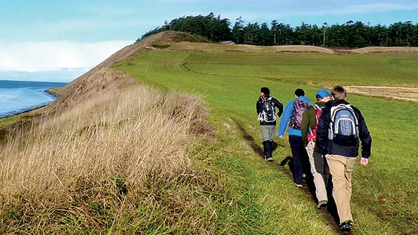
Ebey’s Landing, Whidbey Island — Colonel Isaac Neff Ebey settled on Whidbey Island in the 1850s and built a blockhouse there to protect his land. Today, the structure still stands sentinel over prairies that have been farmed continually for 150 years at what is now called Ebey’s Landing. This stunning hike has a short climb up windswept coastal bluffs and past twisted firs, grass fields like a scene from The Lord of the Rings, and great views over the Strait of Juan de Fuca.
DISTANCE — 5.6 miles round-trip
ELEVATION GAIN — 260 feet
GO FOR — Costal allure
PENINSULAS AND COAST

Shi Shi Beach, Olympic Peninsula— Added to Olympic National Park in 1976, Shi Shi has long been a favorite spot of First Peoples, naturalists, day-hikers, bird-watchers, and surfers. Just meander through Sitka spruce, inch down a steep bluff trail, and you’re there: staring south at two miles of one of the Northwest’s most beautiful beaches. It’s hard to imagine a better place on the Olympic Coast to take in the powerful, rugged beauty of the wilderness.
DISTANCE — 8 miles round trip
ELEVATION GAIN — 1,000 feet
GO FOR — Unblemished beach
NORTH CASCADES

Hidden Lake Lookout — Keep your eyes peeled on this sensational hike, featuring clear meadows, massive slabs of granite, a fire lookout, and other visual riches. For the first two and a half miles, the route crosses and recrosses East Fork Sibley Creek and gains enough elevation to showcase Mount Baker to the west. At three miles, you may encounter a snow gully; don’t proceed without an ice ax. If the route is safe, hike on to more meadows and mountain views, then on up to the 6,890-foot knoll with its 1931 fire lookout.
DISTANCE — 9 miles round trip
ELEVATION GAIN — 3,290 feet
GO FOR — Prime peak views
NORTH CENTRAL

Maple Pass — From the North Cascades Highway at Rainy Pass, this loop leads past old-growth groves, picturesque meadows, and shimmering lakes; across melting snowfields blooming with glacier lilies; through fields abloom with paintbrush and penstemon; and to stunning Cascade vistas. If you don’t have time for the full loop, you can also do a short hike to Rainy Lake from this trailhead.
DISTANCE — 7.2 miles round trip
ELEVATION GAIN — 2,000 feet
GO FOR — Wildflowers galore
THE GORGE

Silver Star Mountain — Traversing a meadowlined ridge high above the Columbia River Gorge, where big-leaf maples, cottonwood, and Oregon ash contrast dramatically against basalt cliffs and dark green conifers in autumn, this four-mile trail is a South Cascades favorite. The trail leads up to the Silver Star summit—at 4,300 feet, it has enough altitude to let you see all the way to Portland.
DISTANCE — 4 miles round trip
ELEVATION GAIN — 1000 feet
GO FOR — Fall foliage
NORTHEAST

Liberty Lake Regional Park — Eight miles of trail lead along the valley floor, crossing the creek on footbridges, then climb up a series of steep switchbacks. Old-growth cedar— some of the last left in Spokane County—provides plenty of shade, while a waterfall that cascades throughout the year, but particularly in spring, is another trip highlight.
DISTANCE — 8 miles round trip
ELEVATION GAIN — 1,200 feet
GO FOR — Cool cedar groves
WINE COUNTRY

Yakima Skyline Ridge Trail — Within the L. T. Murray State Wildlife Recreation Area, a desert trail cuts across rolling, brown hills, featuring heady blooms and color in spring, plus a diversity of birds and mammals. You might see quail, partridges, hawks, elk, badgers, and even bighorn sheep. Park at the trailhead, or stop a half mile short and climb the ridge straight in front of you for the best views; at the top, turn left to meet up with the official trail.
DISTANCE — 8 miles round trip
ELEVATION GAIN — 1,000 feet
GO FOR — Dramatic desert
SOUTHEAST

Palouse Falls — The waters of Palouse Falls plunge 198 feet into a cinder-rock bowl below. Drink in your fill of the majestic scenery, then follow the marked path north for a riot of colorful wildflowers in spring and early summer. The trail leads out of the parking area, across a plateau, and alongside railroad tracks before looping back down for a nice two-mile stroll.
DISTANCE — 2 miles round trip
ELEVATION GAIN — 293 feet
GO FOR — Waterfall spectacle
WILD IN THE CITY
With millions—yes, millions—of acres of state and national forests and three major national parks, Washington has no shortage of great hiking destinations. But don’t count out the state’s urban areas just yet: Washington’s bustling cities offer some excellent hiking, too. Here are half a dozen trails that let you go wild in the city.
Everett
SPENCER ISLAND
of mountain and forest, canyon and desert, Washington state is laced with unpaved, unsmoothed offroad mountain biking trails that range from moderately challenging to expert. The state’s national forests, which blanket the Cascades and Blue Mountains, and skirt Olympic National Park in the Olympics, hold numerous trails open to recreational bikers.
Olympia
PRIEST POINT PARK
Savor the serenity of this outdoor sanctuary—largely unchanged since 1848 when Father Pascal Ricard built his mission here—by ambling two and a half miles around Ellis Cove on the trail and boardwalk. Marvel at century-old firs and maples, and explore quiet beaches in this 300-acre park just north of the state capitol. Visit olympiawa.gov; search for “Priest Point Park.”
Vancouver
FRENCHMAN’S BAR TRAIL
A delightfully level five-mile path across fertile Columbia River bottomlands takes you from sprawling, wildlife-rich Vancouver Lake to riverside Frenchman’s Bar. Marvel at big ships rolling on the river, and soak up sensational views of snowy volcanic sentinels Mounts Hood and St. Helens. Visit cityofvancouver. us; search for “Frenchman’s Bar Trail.”
Bellingham
WHATCOM FALLS PARK
Wander a network of trails through groves of ancient forest, and drop into a mist-soaked ravine to reach a Depression-era archedsandstone bridge that spans Whatcom Creek at the base of a thundering waterfall. Trails fan out from this 241- acre park to Whatcom Lake and Bellingham Bay. Visit cob.org; search for “Whatcom Falls Park.”
Tri-Cities
SACAGAWEA HERITAGE TRAIL
From the confluence of the Snake and Columbia Rivers, this 23-mile paved path weaves together all three of the Tri-Cities. There are plenty of surprises to discover along the way, including Lewis and Clark interpretive sites, sculptures, riverside parks, nature preserves, and the Cable Bridge—a popular local landmark. friendsofourtrail.com
Spokane
CENTENNIAL TRAIL
Follow the Spokane River through town and country on this 37-mile paved trail from the Idaho border to 10,000- acre Riverside State Park. Trek through tranquil pine forests and bustling downtown Spokane and admire waterfalls, unusual geological features, and unique bridges along the way. Visit spokanecentennialtrail.org.
— Craig Romano


